Geologic information#
Description: Download fault locations, geologic unit boundaries, and source information for Antarctic from the GeoMAP compilation.
Dataset:
Cox, Simon Christopher, Belinda Smith Lyttle, Samuel Elkind, Christine S. Smith Siddoway, Paul Morin, Giovanni Capponi, Tamer Abu-Alam, et al. “The GeoMAP (v.2022-08) Continent-Wide Detailed Geological Dataset of Antarctica.” PANGAEA, 2023. https://doi.org/10.1594/PANGAEA.951482.
Associated paper:
Cox, Simon C., Belinda Smith Lyttle, Samuel Elkind, Christine Smith Siddoway, Paul Morin, Giovanni Capponi, Tamer Abu-Alam, et al. “A Continent-Wide Detailed Geological Map Dataset of Antarctica.” Scientific Data 10, no. 1 (May 18, 2023): 250. https://doi.org/10.1038/s41597-023-02152-9.
[1]:
%%capture
%load_ext autoreload
%autoreload 2

from polartoolkit import fetch, maps, regions
[2]:
fetch.geomap(
    version="faults",
    # available options
    # region,
)
[2]:
| objectid | NAME | DESCR | TYPENAME | TYPE_URI | ACCURACY | EXPOSURE | ACTIVITY | DEFRMSTYLE | DEFRM_URI | ... | RESSCALE | CAPTSCALE | CAPTDATE | MODDATE | PLOTRANK | FEATUREID | SPEC_URI | SYMBOL | Shape_Length | geometry | |
|---|---|---|---|---|---|---|---|---|---|---|---|---|---|---|---|---|---|---|---|---|---|
| 0 | 1 | fault (inactive) | fault | http://resource.geosciml.org/classifier/cgi/fa... | approximate | concealed | inactive | unknown | http://www.opengis.net/def/nil/OGC/0/unknown | ... | 500000 | 50000 | 2019-04-15 | 2019-04-03 | 250000 | ATA_GeoMAP_faults_00001 | http://www.opengis.net/def/nil/OGC/0/missing | 3.989215e+03 | MULTILINESTRING ((-2631789.265 1593859.332, -2... | ||
| 1 | 2 | fault (inactive) | fault | http://resource.geosciml.org/classifier/cgi/fa... | approximate | concealed | inactive | unknown | http://www.opengis.net/def/nil/OGC/0/unknown | ... | 500000 | 50000 | 2019-04-15 | 2019-04-03 | 250000 | ATA_GeoMAP_faults_00002 | http://www.opengis.net/def/nil/OGC/0/missing | 4.860209e+03 | MULTILINESTRING ((-2626731.089 1595742.734, -2... | ||
| 2 | 3 | fault (inactive) | fault | http://resource.geosciml.org/classifier/cgi/fa... | approximate | exposed | inactive | unknown | http://www.opengis.net/def/nil/OGC/0/unknown | ... | 500000 | 50000 | 2019-04-15 | 2019-04-03 | 250000 | ATA_GeoMAP_faults_00003 | http://www.opengis.net/def/nil/OGC/0/missing | 2.576661e+03 | MULTILINESTRING ((-2625953.454 1597731.139, -2... | ||
| 3 | 4 | fault (inactive), feature inferred | fault | http://resource.geosciml.org/classifier/cgi/fa... | uncertain | unknown | inactive | unknown | http://www.opengis.net/def/nil/OGC/0/unknown | ... | 500000 | 50000 | 2019-04-15 | 2019-04-03 | 250000 | ATA_GeoMAP_faults_00004 | http://www.opengis.net/def/nil/OGC/0/missing | 2.164953e+03 | MULTILINESTRING ((-2623736.366 1598522.161, -2... | ||
| 4 | 5 | fault (inactive) | fault | http://resource.geosciml.org/classifier/cgi/fa... | approximate | exposed | inactive | unknown | http://www.opengis.net/def/nil/OGC/0/unknown | ... | 500000 | 50000 | 2019-04-15 | 2019-04-03 | 250000 | ATA_GeoMAP_faults_00005 | http://www.opengis.net/def/nil/OGC/0/missing | 2.518667e+03 | MULTILINESTRING ((-2638573.876 1584988.955, -2... | ||
| ... | ... | ... | ... | ... | ... | ... | ... | ... | ... | ... | ... | ... | ... | ... | ... | ... | ... | ... | ... | ... | ... |
| 1779 | 1787 | geological province boundary within tectonic b... | suture (inactive), feature inferred | fault | http://resource.geosciml.org/classifier/cgi/fa... | uncertain | unknown | inactive | unknown | http://www.opengis.net/def/nil/OGC/0/unknown | ... | 10000000 | 1000000 | 2020-10-01 | 2022-07-18 | 500000 | ATA_GeoMAP_faults_01780 | http://www.opengis.net/def/nil/OGC/0/missing | 4.427161e+05 | MULTILINESTRING ((-1381344.657 500083.051, -13... | |
| 1780 | 1788 | geological province boundary within tectonic b... | suture (inactive), feature inferred | fault | http://resource.geosciml.org/classifier/cgi/fa... | uncertain | unknown | inactive | unknown | http://www.opengis.net/def/nil/OGC/0/unknown | ... | 10000000 | 1000000 | 2020-10-01 | 2022-07-18 | 500000 | ATA_GeoMAP_faults_01781 | http://www.opengis.net/def/nil/OGC/0/missing | 4.919584e+05 | MULTILINESTRING ((-1475007.344 98444.748, -144... | |
| 1781 | 1789 | geological province boundary within tectonic b... | suture (inactive), feature inferred | fault | http://resource.geosciml.org/classifier/cgi/fa... | uncertain | unknown | inactive | unknown | http://www.opengis.net/def/nil/OGC/0/unknown | ... | 10000000 | 1000000 | 2020-10-01 | 2022-07-18 | 500000 | ATA_GeoMAP_faults_01782 | http://www.opengis.net/def/nil/OGC/0/missing | 2.514158e+05 | MULTILINESTRING ((-1018864.765 259840.904, -97... | |
| 1782 | 1790 | geological province boundary within tectonic b... | suture (inactive), feature inferred | fault | http://resource.geosciml.org/classifier/cgi/fa... | uncertain | unknown | inactive | unknown | http://www.opengis.net/def/nil/OGC/0/unknown | ... | 10000000 | 1000000 | 2020-10-01 | 2022-07-18 | 500000 | ATA_GeoMAP_faults_01783 | http://www.opengis.net/def/nil/OGC/0/missing | 1.492810e+06 | MULTILINESTRING ((-156648.686 -277229.846, -15... | |
| 1783 | 1791 | geological province boundary within tectonic b... | suture (possibly active), feature inferred | fault | http://resource.geosciml.org/classifier/cgi/fa... | uncertain | unknown | possibly active | unknown | http://www.opengis.net/def/nil/OGC/0/unknown | ... | 10000000 | 1000000 | 2020-10-01 | 2022-07-18 | 500000 | ATA_GeoMAP_faults_01784 | http://www.opengis.net/def/nil/OGC/0/missing | 1.170610e+06 | MULTILINESTRING ((-1657570.209 -497398.111, -1... |
1784 rows × 35 columns
[3]:
version_names = [
    "faults",
    "units",
    # "sources", # not interesting to plot
    # "quality", # not interesting to plot
]


data = []
for name in version_names:
    d = fetch.geomap(
        version=name,
        # available options
        # region,
    )
    # only keep subset of largest units to speed up the plotting below
    if name == "units":
        d = d.sort_values(by="Shape_Area", ascending=False).copy()
        d = d.iloc[0 : int(len(d) / 4)]  # largest 1/4 of shapes
    data.append(d)
[4]:
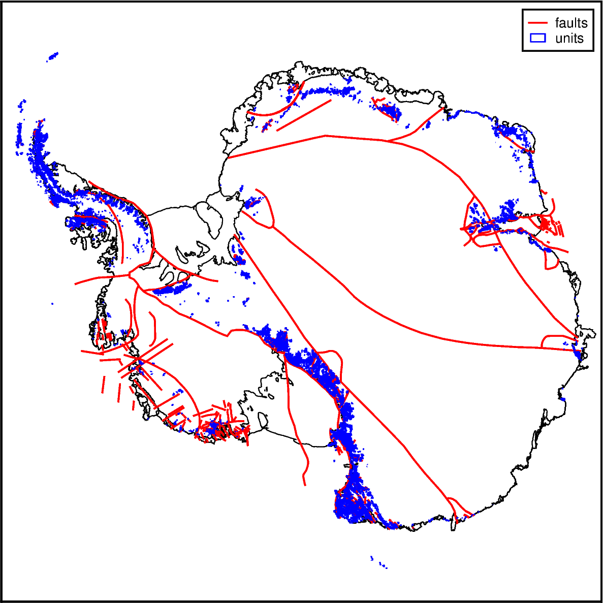
fig = maps.basemap(
    region=regions.antarctica,
    hemisphere="south",
    coast=True,
)


# plot the shapefiles
pens = ["1.2p,red", ".8p,blue"]
for i, v in enumerate(version_names):
    fig.plot(data[i], pen=pens[i], label=v)

# add a legend
fig.legend()

fig.show(dpi=200)
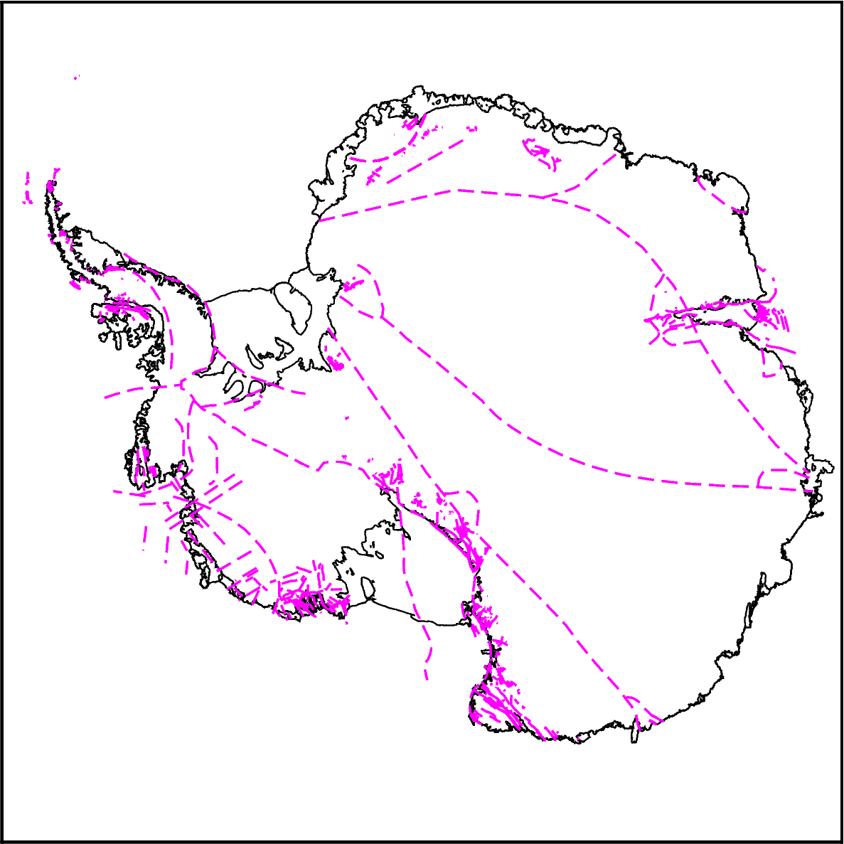
Plotting faults#
You can also use the function maps.add_faults for an easy way to specify and plot faults.
[5]:
fig = maps.basemap(
    region=regions.antarctica,
    hemisphere="south",
    coast=True,
)

# with defaults
maps.add_faults(
    fig=fig,
)

fig.show(dpi=200)
/tmp/ipykernel_276993/417637984.py:8: DeprecatedWarning: add_faults is deprecated as of 1.0.7 and will be removed in 2.0.0. `add_faults` has been replaced with a class method.
  maps.add_faults(
[6]:
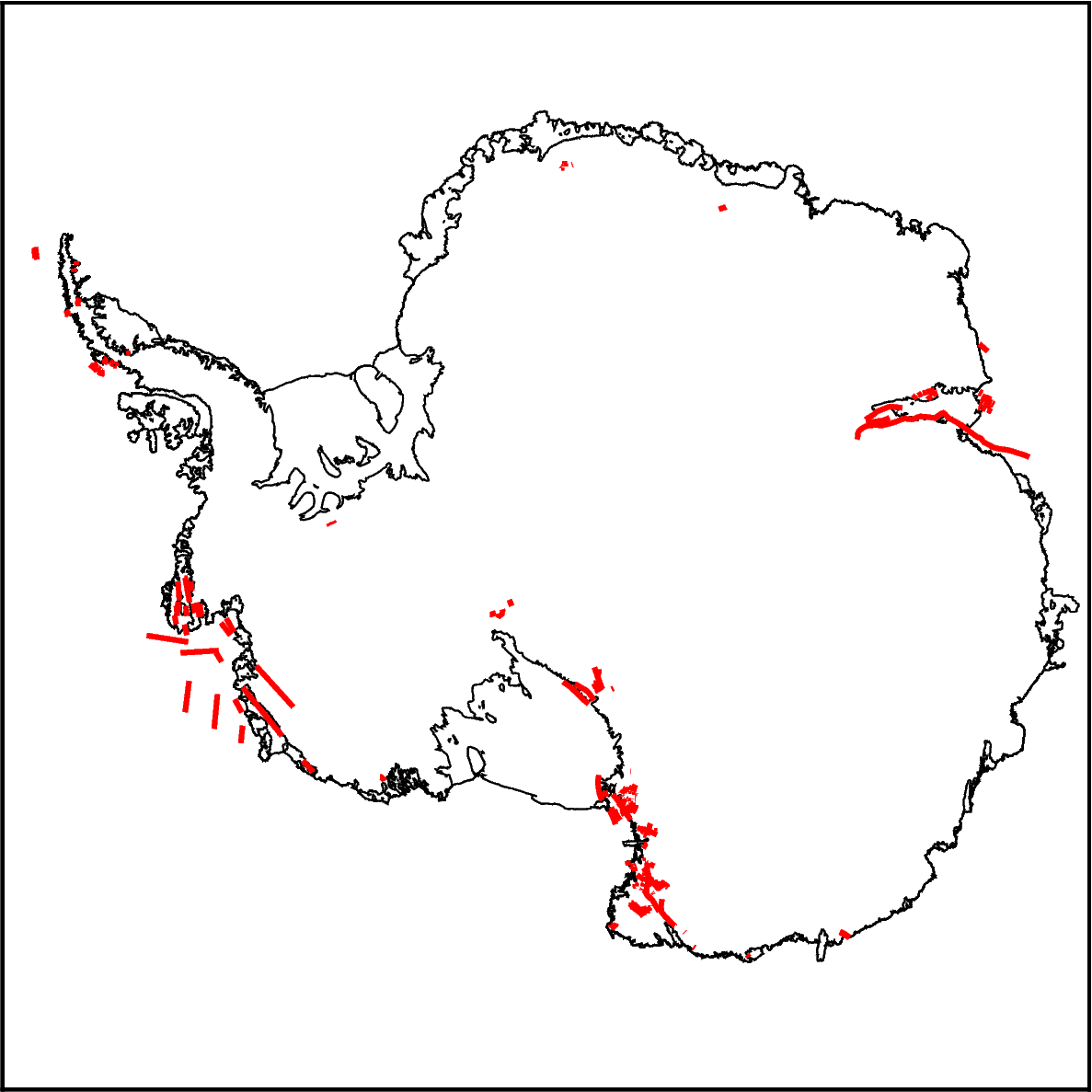
fig = maps.basemap(
    region=regions.antarctica,
    hemisphere="south",
    coast=True,
)

# specifying fault types
maps.add_faults(
    fig=fig,
    fault_activity="inactive",
    fault_motion="normal",
    fault_exposure="inferred",
    pen="2p,red",
)

fig.show(dpi=200)
/tmp/ipykernel_276993/2043500127.py:8: DeprecatedWarning: add_faults is deprecated as of 1.0.7 and will be removed in 2.0.0. `add_faults` has been replaced with a class method.
  maps.add_faults(
[ ]: