Geothermal Heat Flux#
Datasets:
Martos, Yasmina M. “Antarctic Geothermal Heat Flux Distribution and Estimated Curie Depths, Links to Gridded Files.” Supplement to: Martos, Yasmina M; Catalán, Manuel; Jordan, Tom A; Golynsky, Alexander V; Golynsky, Dmitry A; Eagles, Graeme; Vaughan, David G (2017): Heat Flux Distribution of Antarctica Unveiled. Geophysical Research Letters, 44(22), 11417-11426, Https://Doi.Org/10.1002/2017GL075609. PANGAEA, 2017. https://doi.org/10.1594/PANGAEA.882503.
Lösing, Mareen, and Jörg Ebbing. “Predicted Antarctic Heat Flow and Uncertainties Using Machine Learning.” PANGAEA, 2021. https://doi.org/10.1594/PANGAEA.930237.
Stål, Tobias, Anya M. Reading, Jacqueline A. Halpin, and Joanne Whittaker. “Antarctic Geothermal Heat Flow Model: Aq1.” PANGAEA, 2020. https://doi.org/10.1594/PANGAEA.924857.
Hazzard, J. A. N., & Richards, F. D. (2024). Antarctic geothermal heat flow, crustal conductivity and heat production inferred from seismological data [Dataset]. OSF. Retrieved from https://osf.io/54zam
Haeger, Carina; Petrunin, Alexey G.; Kaban, Mikhail K. (2022): Geothermal heat flow and thermal structure of the Antarctic lithosphere. GFZ Data Services. https://doi.org/10.5880/GFZ.1.3.2022.002
Associated papers:
An, Meijian, Douglas A. Wiens, Yue Zhao, Mei Feng, Andrew Nyblade, Masaki Kanao, Yuansheng Li, Alessia Maggi, and Jean‐Jacques Lévêque. “Temperature, Lithosphere‐asthenosphere Boundary, and Heat Flux beneath the Antarctic Plate Inferred from Seismic Velocities.” Journal of Geophysical Research: Solid Earth 120, no. 12 (December 2015): 8720–42. https://doi.org/10.1002/2015JB011917.
Martos, Yasmina M., Manuel Catalán, T. A. Jordan, Alexander Golynsky, Dmitry Golynsky, Graeme Eagles, and David G. Vaughan. “Heat Flux Distribution of Antarctica Unveiled.” Geophysical Research Letters 44 (November 28, 2017): 1–10. https://doi.org/10.1002/2017GL075609.
Burton-Johnson, Alex, Ricarda Dziadek, and Carlos Martin. “Geothermal Heat Flow in Antarctica: Current and Future Directions.” The Cryosphere Discussions, 2020, 1–45. https://doi.org/10.5194/tc-2020-59.
Lösing, M., and J. Ebbing. “Predicting Geothermal Heat Flow in Antarctica With a Machine Learning Approach.” Journal of Geophysical Research: Solid Earth 126, no. 6 (June 2021). https://doi.org/10.1029/2020JB021499.
Stål, Tobias, Anya M. Reading, Jacqueline A. Halpin, and Joanne M. Whittaker. “Antarctic Geothermal Heat Flow Model: Aq1.” Geochemistry, Geophysics, Geosystems 22, no. 2 (February 2021). https://doi.org/10.1029/2020GC009428.
Shen, Weisen, Douglas A. Wiens, Andrew J. Lloyd, and Andrew A. Nyblade. “A Geothermal Heat Flux Map of Antarctica Empirically Constrained by Seismic Structure.” Geophysical Research Letters 47, no. 14 (2020). https://doi.org/10.1029/2020GL086955.
Hazzard, J. A. N., & Richards, F. D. (2024). Antarctic geothermal heat flow, crustal conductivity and heat production inferred from seismological data. Geophysical Research Letters, 51, e2023GL106274. https://doi.org/10.1029/2023GL106274
Haeger, C., Petrunin, A. G., & Kaban, M. K. (2022). Geothermal heat flow and thermal structure of the Antarctic lithosphere. Geochemistry, Geophysics, Geosystems, 23, e2022GC010501. https://doi.org/10.1029/2022GC010501
[1]:
import polartoolkit as ptk
[4]:
version_names = [
    "an-2015",
    "martos-2017",
    "burton-johnson-2020",
    "losing-ebbing-2021",
    "aq1",
    "shen-2020",
    "hazzard-richards-2024",
    "haeger-2024",
]

grids = []
for name in version_names:
    data = ptk.fetch.ghf(
        version=name,
        # available options
        # region,
        # spacing,
        # registration ("g" for gridline or "p" for pixel),
    )
    grids.append(data)
    print(f"Info for {name}")
    _ = ptk.get_grid_info(data, print_info=True)
    print("##########")
Info for an-2015
grid spacing: 5000.0 m
grid region: (-3330000.0, 3330000.0, -3330000.0, 3330000.0)
grid zmin: 26.5443553925
grid zmax: 102.38230896
grid registration: g
##########
Info for martos-2017
grid spacing: 15000.0 m
grid region: (-2535000.0, 2715000.0, -2130000.0, 2220000.0)
grid zmin: 42.6263694763
grid zmax: 240.510910034
grid registration: g
##########
Info for burton-johnson-2020
grid spacing: 17000.0 m
grid region: (-2543500.0, 2624500.0, -2121500.0, 2213500.0)
grid zmin: 42.2533454895
grid zmax: 106.544433594
grid registration: p
##########
Info for losing-ebbing-2021
Warning 1: The definition of projected CRS EPSG:3031 got from GeoTIFF keys is not the same as the one from the EPSG registry, which may cause issues during reprojection operations. Set GTIFF_SRS_SOURCE configuration option to EPSG to use official parameters (overriding the ones from GeoTIFF keys), or to GEOKEYS to use custom values from GeoTIFF keys and drop the EPSG code.
grid spacing: 5000.0 m
grid region: (-2800000.0, 2800000.0, -2800000.0, 2800000.0)
grid zmin: 31.1965789795
grid zmax: 156.956375122
grid registration: g
##########
Info for aq1
grid spacing: 20000.0 m
grid region: (-2800000.0, 2800000.0, -2800000.0, 2800000.0)
grid zmin: 24.3441848755
grid zmax: 195.456390381
grid registration: g
##########
Info for shen-2020
grid spacing: 10000.0 m
grid region: (-2800000.0, 2800000.0, -2800000.0, 2800000.0)
grid zmin: 40.061290741
grid zmax: 85.3333892822
grid registration: g
##########
Info for hazzard-richards-2024
grid spacing: 5000.0 m
grid region: (-2525000.0, 2770000.0, -2155000.0, 2225000.0)
grid zmin: 20.4779720306
grid zmax: 128.475723267
grid registration: g
##########
Info for haeger-2024
grid spacing: 10000.0 m
grid region: (-3700000.0, 3700000.0, -3700000.0, 3700000.0)
grid zmin: 32.7274017334
grid zmax: 81.4344024658
grid registration: g
##########
[6]:
burton_johnson_points = ptk.fetch.ghf(
    version="burton-johnson-2020",
    points=True,
)
burton_johnson_points
[6]:
| lat | lon | Station ID | top (m) | bot (m) | grad | k(W/mK) | GHF | err | Elevation (m.a.s.l.) | Reference | DOI | DataQuality | Method | Comment | x | y | |
|---|---|---|---|---|---|---|---|---|---|---|---|---|---|---|---|---|---|
| 0 | -56.5667 | 34.1833 | C11-44 | 0.0 | 11 | 300 | 0.77 | 229.0 | NaN | -5372.0 | Anderson1977 | https://doi.org/10.1594/PANGAEA.796541 | S3 | Unconsolidated sediments | NaN | 2.098568e+06 | 3.089886e+06 |
| 1 | -56.3000 | 51.9667 | C11-45 | 0.0 | 11 | 19 | 0.72 | 14.0 | NaN | -5386.0 | Anderson1977 | https://doi.org/10.1594/PANGAEA.796541 | S3 | Unconsolidated sediments | NaN | 2.966827e+06 | 2.320718e+06 |
| 2 | -52.7000 | 54.0000 | C11-47 | 0.0 | 11 | 90 | 0.72 | 65.0 | NaN | -4585.0 | Anderson1977 | https://doi.org/10.1594/PANGAEA.796541 | S3 | Unconsolidated sediments | NaN | 3.394980e+06 | 2.466597e+06 |
| 3 | -50.4667 | 59.5833 | C11-48 | 0.0 | 7 | 360 | 0.75 | 271.0 | NaN | -4839.0 | Anderson1977 | https://doi.org/10.1594/PANGAEA.796541 | S3 | Unconsolidated sediments | NaN | 3.852572e+06 | 2.261800e+06 |
| 4 | -50.3167 | 61.2000 | C11-49 | 0.0 | 11 | 120 | 0.68 | 81.0 | NaN | -4640.0 | Anderson1977 | https://doi.org/10.1594/PANGAEA.796541 | S3 | Unconsolidated sediments | NaN | 3.930916e+06 | 2.161039e+06 |
| ... | ... | ... | ... | ... | ... | ... | ... | ... | ... | ... | ... | ... | ... | ... | ... | ... | ... |
| 443 | -61.1000 | -19.8500 | IO15-49 | NaN | 10 | 0.81 | 84.0 | -4764.0 | Zlotnicki1980 | https://doi.org/10.1029/GL007i006p00421 | S2 | Unconsolidated sediments | bot (m) from depths in https://doi.org/10.1029... | -1.088517e+06 | 3.015213e+06 | ||
| 444 | -66.2500 | -33.0667 | IO15-52 | NaN | 11 | 0.86 | 64.0 | -4933.0 | Zlotnicki1980 | https://doi.org/10.1029/GL007i006p00421 | S2 | Unconsolidated sediments | bot (m) from depths in https://doi.org/10.1029... | -1.427655e+06 | 2.192803e+06 | ||
| 445 | -64.0667 | -36.9500 | IO15-55 | NaN | 6 | 1.25 | 175.0 | -4797.0 | Zlotnicki1980 | https://doi.org/10.1029/GL007i006p00421 | S2 | Unconsolidated sediments | bot (m) from depths in https://doi.org/10.1029... | -1.722133e+06 | 2.289502e+06 | ||
| 446 | -63.1000 | -38.4500 | IO15-56 | NaN | 8 | 1.03 | 105.0 | -4495.0 | Zlotnicki1980 | https://doi.org/10.1029/GL007i006p00421 | S2 | Unconsolidated sediments | bot (m) from depths in https://doi.org/10.1029... | -1.850246e+06 | 2.330250e+06 | ||
| 447 | -55.6500 | -41.1667 | IO15-64 | NaN | 6 | 0.87 | 81.0 | -3458.0 | Zlotnicki1980 | https://doi.org/10.1029/GL007i006p00421 | S2 | Unconsolidated sediments | bot (m) from depths in https://doi.org/10.1029... | -2.530093e+06 | 2.893493e+06 |
446 rows × 17 columns
[7]:
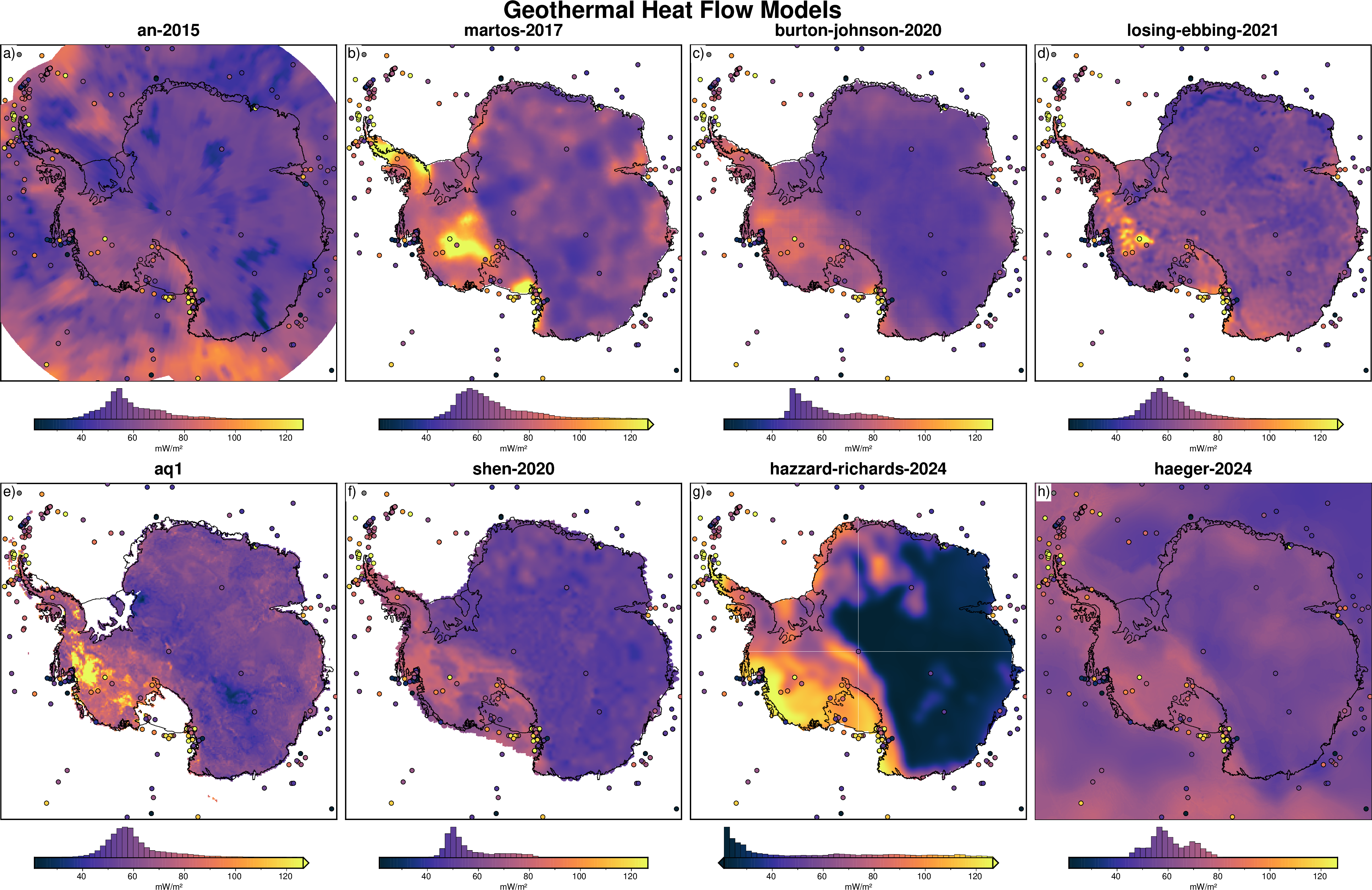
cpt_lims = ptk.get_combined_min_max(grids, robust=True)

fig = ptk.subplots(
    grids,
    region=ptk.regions.antarctica,
    fig_title="Geothermal Heat Flow Models",
    titles=version_names,
    cbar_label="mW/m²",
    coast=True,
    cmap="thermal",
    cpt_lims=cpt_lims,
    hemisphere="south",
    points=burton_johnson_points,
    points_fill="GHF",
    points_pen=".6p,black",
    hist=True,
)

fig.show(dpi=200)
/home/mdtanker/miniforge3/envs/polartoolkit/lib/python3.12/site-packages/pygmt/clib/session.py:668: RuntimeWarning: The definition of projected CRS EPSG:3031 got from GeoTIFF keys is not the same as the one from the EPSG registry, which may cause issues during reprojection operations. Set GTIFF_SRS_SOURCE configuration option to EPSG to use official parameters (overriding the ones from GeoTIFF keys), or to GEOKEYS to use custom values from GeoTIFF keys and drop the EPSG code.
  status = c_call_module(self.session_pointer, module.encode(), mode, argv)